COMMON WEALTH: REINSCRIBING THE PAST
A COMMUNITY ART COLLABORATION (Led by Professor Michael Kopp)
Bellarmine University: (Art 346 H) Art in Community - Spring 2025
“As part of our community art course (Bellarmine University, Spring 2025), we undertook a collaborative research and art-making project that explores the deep interconnections between horses and the peoples of the Commonwealth of Kentucky. Rooted in place-based inquiry, this project investigates histories often left at the margins: the legacy of Black horsemen, jockeys, and trainers; the cultural labor of W.P.A. Packhorse Librarians in Appalachia; and the essential contributions of midwife nurses—known as “Angels on Horseback”—who served rural Appalachian communities.
Our aim is to critically examine how these narratives intersect with Kentucky’s broader identity, especially in relation to the horse racing industry and rural life. Through archival research, storytelling, and creative collaboration, we seek to surface histories that have been obscured by dominant narratives, revealing the complexity and resilience of the communities involved.
The digital art produced in this project was required to adopt a scrapbook aesthetic, serving both as a conceptual and visual reference to the cultural history of Eastern Kentucky—specifically, the American scrapbooking tradition that emerged in connection with the WPA Pack Horse Librarian program during the Great Depression. This aesthetic choice pays tribute to a practice rooted in storytelling, preservation, and community memory, especially within the Appalachian region.
A scrapbook aesthetic evokes a layered, handmade, and highly personal visual language. This collaborative digital project mimics the look and feel of traditional scrapbooks, incorporating mixed media elements and a sense of nostalgic materiality. The goal is to reflect the emotional, archival, and often imperfect qualities of memory work—aligning with the community-centered spirit of this research project.
As such, this project is both reflective and generative. As artists, students and community members, we worked to bridge historical research with contemporary artistic practices in ways that engage the public, invite dialogue, and foster collective memory. The resulting artworks and installations are intended not only to celebrate Kentucky’s heritage, but also to prompt meaningful conversations about identity, equity, and our shared future.”
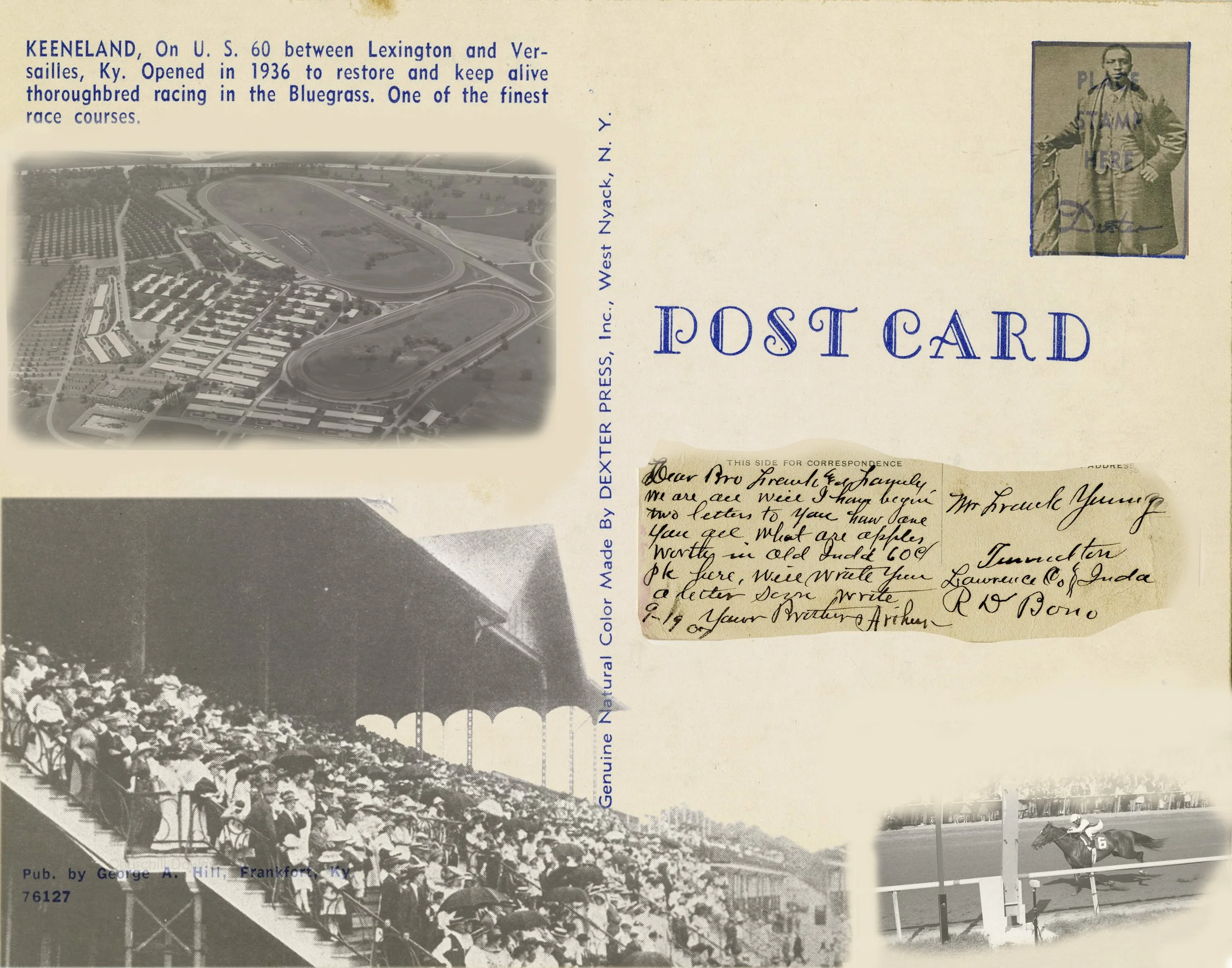
UNEARTHING THE LEGACY: BLACK HORSEMEN IN KENTUCKY’S RACING HISTORY
“Our group focused on the often-overlooked legacy of Black horsemen in Kentucky—jockeys, trainers, and caretakers whose expertise and labor were foundational to the early success of American horse racing. Despite their historic contributions, these individuals have been largely erased from mainstream narratives in favor of their white counterparts. Through research and creative practice, we aim to surface these hidden stories and honor the enduring influence of Black horsemen on Kentucky’s cultural and equestrian heritage.
Delving into archival photographs, historical documents, and geographic records, we began uncovering traces of a broader, underrepresented history. From renowned jockeys and legendary horses to overlooked training grounds and race tracks, our project maps a lineage of excellence and resilience shaped by both systemic injustice and personal triumph. This research has ignited a collective fascination and sense of responsibility to preserve and elevate these stories.
Our visual responses use layered collage, geographic references, and symbolic textures to reassert the presence of Black horsemen within Kentucky’s visual and cultural landscape. Each piece serves as both tribute and intervention—inviting viewers to reflect on whose histories are preserved, whose are silenced, and how art can serve as a means of reparation and remembrance.
Through this project, we seek not only to honor those whose legacies have been marginalized but also to spark dialogue about visibility, equity, and the ongoing work of reclaiming Kentucky’s full racing history.”


ANGELS ON HORSEBACK: A STUDY ON RURAL CARE AND RESILIENCE
“As part of our community art collaboration, our group focused on the Angels on Horseback—a term given to the pioneering nurses of the Frontier Nursing Service (FNS), founded by Mary Breckinridge in early 20th-century Appalachia. Drawing from the KET documentary, we explored how these women delivered vital maternal and family health care to remote mountain communities, often traveling on horseback through rugged terrain and harsh weather to reach patients.
Our research highlighted the visionary work of Breckinridge and the broader network of women who joined her, including many international nurses. Although the scope of the FNS never fully met Breckinridge’s aspirations, its impact on rural healthcare access was profound, laying the groundwork for more equitable medical services in underserved regions.
As a group, we were especially drawn to the physical and emotional landscapes these nurses navigated—their daily routes across difficult terrain, the architecture of clinics and homes, and the evolving practices of nursing in the 20th century. This project helped us reflect on how place, care, and courage intersect in Kentucky’s history, and how these narratives continue to resonate with contemporary struggles for healthcare justice and community support.”


PACKHORSE LIBRARIANS: LITERACY ON THE MOVE IN APPALACHIA KENTUCKY
“In our community art course, our group focused on the Packhorse Library Program (1935–1943), a New Deal initiative supported by Eleanor Roosevelt and the Works Progress Administration. Born from the challenges of the Great Depression, the program empowered local women to deliver books on horseback to remote communities throughout Appalachia—bringing literature, news, and opportunity to people with limited access to formal education or libraries.
This research led us to reflect on the ways literacy and labor intersected in this era, and how mobility—both physical and social—became a lifeline for many Appalachian families. The Packhorse Librarians not only increased literacy rates across the region but also forged new pathways for women’s employment and autonomy. Their work offers a powerful lens through which to examine the resilience of rural communities and the critical role of knowledge-sharing in shaping Kentucky’s future.
Through our individual and collective projects, we explored themes such as the history of literacy in Appalachia, the complex beauty of the region’s geography, and the emotional terrain of isolation and connection. Using digital tools, we created layered visual composites and animated GIFs that incorporate archival images, historical and contemporary maps, and photographs of the Appalachian landscape. Our intent was to bridge past and present—blending image, history, and place to reimagine this chapter of Kentucky’s heritage.
By engaging with the Packhorse Librarians through visual storytelling, we hope to honor their legacy and invite new conversations about access, education, and the endurance of community care in the face of adversity.”


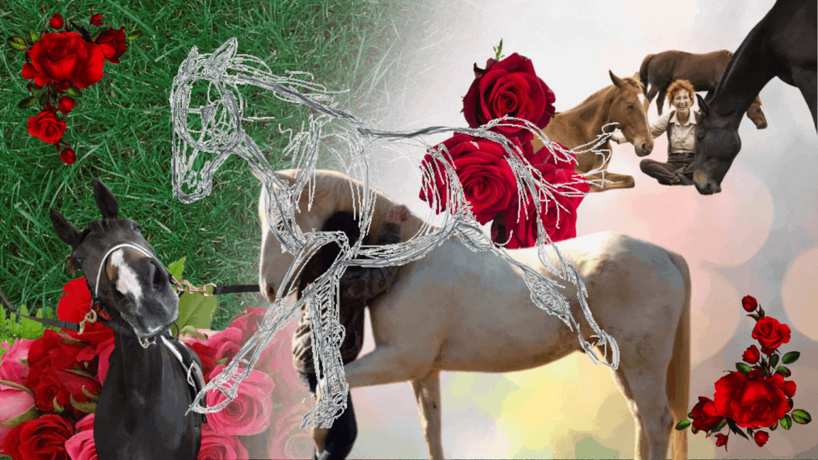
THOROUGHBRED LEGACIES: POWER, LABOR, AND TRADITION IN KENTUCKY’S HORSE INDUSTRY
“Our group explored the complex histories and contemporary realities of Kentucky’s Thoroughbred racing industry, focusing especially on the cultural mythology of the Kentucky Derby and the often-unseen labor, politics, and ethics that underpin it. While the Derby is celebrated as “the fastest two minutes in sports,” our research looks beyond the spectacle—examining the lives of the horses, the rigorous training and breeding practices, and the human labor, often marginalized, that makes this tradition possible.
Kentucky’s identity is deeply entwined with the Thoroughbred industry, where decades of selective breeding have created a powerful and elite class of racehorses—many originating from a few historic farms. Alongside this legacy, we investigated stories that are less frequently told: the role of women in racing, the physical and emotional toll on both animals and caretakers, and ongoing issues surrounding performance enhancement, animal welfare, and economic inequality within the sport.
In our visual response, we turned to the regional folk tradition of scrapbooking—an intimate, layered storytelling method popularized in Appalachian Kentucky. Using this approach, we created mixed-media pieces that weave together archival material, symbolic imagery, and personal reflections. Our artworks aim to honor the cultural heritage of the Derby while also engaging critically with its complexities—asking viewers to consider what stories are celebrated, which are hidden, and who is ultimately at the center of these enduring traditions.
Through this project, we hope to contribute to a more nuanced understanding of how horses and humans continue to shape one another in Kentucky’s past and present.”


MAIL ORDER KENTUCKY - Ari Eastman (Independent Study)
“In this series of composite images, I investigate Kentucky’s layered history through the lens of horse racing, centering on the entangled narratives of labor, body ownership, and cultural erasure. While the Kentucky Derby is often portrayed as a spectacle of glamour and tradition, my work peels back that surface to expose the deeper legacies of racial injustice, slavery, and the commodification of both human and animal lives.
Drawing from archival footage, historical letters, photographs, and textual sources from Kentucky’s collections, I assemble visual compositions that interrogate how systems of power have shaped—and continue to shape—our cultural narratives. Each image becomes a site of excavation, where past and present collide, revealing the often-dismissed structures that underlie Kentucky’s identity and economy.
Individually, the works address themes of racism, infrastructure, and the economics of exploitation. Together, they weave a critical narrative that questions who wins, who loses, and who is left out of history’s spotlight. Through visual layering and juxtaposition, I aim to confront the viewer with questions about legacy, visibility, and the price of tradition.
This body of work serves as both a tribute and a challenge—urging us to reckon with the histories we inherit and the ways in which they echo through our present. It is an invitation to engage deeply with Kentucky’s complex past in hopes of imagining a more equitable and inclusive future.”


